Skip to content
Ranch Mapper · live · free while in beta

Draw your field. Get the acres. Then ask the ground where the water goes.

Ranch Mapper is a 3D map of your actual ground, running in a browser tab — public 1-meter lidar elevation with aerial imagery draped over it, so the hills, dips, and ditch banks sit where they really are. Outline a field and the acreage lands the second you close the shape. Then the same terrain that draws the map answers questions about it: where water stands after a heavy set, where cold air pools on a clear night, what a 100-foot spray buffer costs you in acres.

  • Free while we're in beta — nothing locked, no credit card, no field limit today
  • Demo mode drops you on sample farmland without touching your data
  • Works offline on ground you've already loaded · your data exports anytime
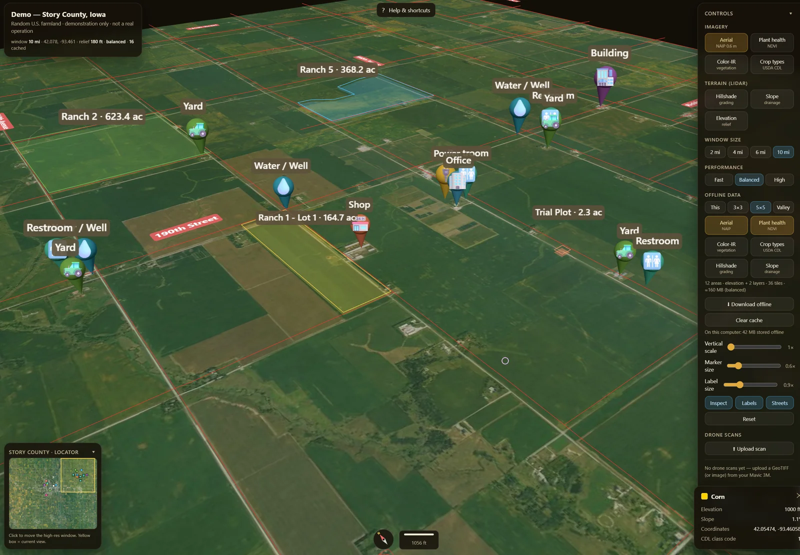
Ranch Mapper — farm fields outlined in 3D on aerial terrain, with the acreage readout visible.

Ranch Mapper — fields outlined on 3D terrain with acreage. Elevation: USGS 3DEP 1 m lidar. Imagery: USDA NAIP. Vertical scale exaggerated for readability. Not a survey.

Built on public data you can go check yourself.

Elevation — USGS 3DEP, 1-meter lidar

The rise and fall of the ground is public government lidar, not our guess and not your drone. Where 3DEP hasn't been flown for your area, or comes back malformed, the map falls back to a coarser public elevation source rather than inventing terrain. Detail is limited to what has actually been flown where you farm.

Imagery — USDA / NAIP aerial, about 0.6 m

What you see draped over the terrain is public aerial photography. It is a snapshot from whenever the last flight was — not today, not live. A field that changed last month still looks like it did on flight day.

Everything else — your browser

The map runs in a browser tab. First launch needs internet to cache the 3D engine; after that it works offline on ground you've already loaded. There is no equipment to connect and no data feed to buy.

We publish the sources because the honest limit of this product is the honest limit of that data, and you can look both of them up. How the terrain loads →

Jobs, answered.

Every block below is a real job and a real tool that's live in the app right now. The last line of each one is what it can't do — we'd rather you find that out here than in the field.

“How many acres is this field, really?”

Find your ground, then click the corners of the field right on the 3D terrain. The moment you close the shape you have the acreage. Name it, color it, group it into a ranch, and it saves. Need distance or a rise-and-fall profile across the field instead? The measure tool gives you running distance, area, and an elevation profile along the line you click.

Where it stops. This is the standard map acre — the flat, top-down area of the outline you drew, computed with no elevation at all, so on hilly ground the real surface is slightly larger. It is the acre the FSA, deeds, and landlords work in, and it is not a legal survey. Verify against a recorded survey before you buy, sell, split, or sign. Measurements taken with the measure tool are scratch work and are not saved with the field.

“Somebody sent me a boundary file and I can't open it.”

Drag in a KML, KMZ, zipped Shapefile, or GeoJSON and your fields land on the terrain with their acreage computed. No GIS install, no license, no conversion service. When you're done, everything comes back out as CSV or GeoJSON, plus a full bundle backup you can hand to your crew.

Where it stops. An imported boundary is only as good as whoever drew it — we don't correct it, we draw it. Coordinate systems are limited to WGS84, UTM, and Web Mercator; a State Plane file is declined by name rather than drawn in the wrong place. Export and backup are free and stay free — they are not a retention lever.

“What did we spray, and when can the crew go back in?”

Log an application against a field — product, date, and the REI (re-entry, hours) and PHI (pre-harvest, days) intervals off the product label — and the countdowns run. You can shade the map by re-entry and pre-harvest status so you can see at a glance which ground is still closed.

Where it stops. The product label is the law, and this is not a compliance determination. You enter the intervals; the app does not know them and will not look them up. A blank interval is treated as unknown — it is never treated as cleared. Spray records live on the device and travel in your bundle backup; they are not part of cloud sync yet, so back them up before you clear a browser.

“I need this to work where there's no signal.”

GPS is satellites, not towers — zero bars stops the imagery, not the fix. Install Ranch Mapper as an app, load your ground while you still have service, and you can draw, measure, drop markers, and keep records out in the dead zone. Sign in with Google or email and your fields, markers, and yield estimates follow you from the truck to the office when you're back in coverage.

Where it stops. The cache is the map — it cannot conjure ground you never loaded, and search is online only. Sync waits for signal. Sync currently covers fields, markers, yield estimates, and ranches; spray records do not sync yet. And this is the map you make, not a live you-are-here dot — it is not a hunting or navigation GPS.

“I need a number for the landlord, the FSA, or the adjuster.”

Keep a dated record per field, in your own units. One-click starter sets pick the vocabulary for row crop, ranch and grazing, orchard, or produce — bushels per acre, tons, AUM, head, bins, boxes — and the whole crop, variety, pack, and unit library is editable. Log estimates and post-harvest actuals, watch the history build season over season, and export the lot.

Where it stops. This is a ledger you keep, not a sensor bolted to the machine. Nothing is measured, verified, or inspected — the numbers are the ones you type. It won't tell you why a field was down, and it won't pick a rate, a variety, or a stocking density. That's your agronomist's and your county extension's work.

“Mark the well, the gate, and the spot that always gives us trouble.”

Drop and label points anywhere on the terrain — wells, gates, pumps, valves, the corner that never dries. They stay put on the ground, sized how you like, and they export with everything else.

Where it stops. Markers are your own notes. Nothing verifies them, and a marker is only as accurate as where you clicked.

Open the Ranch Mapper →

Live on your fields today · beta

What the shape of the land will tell you — and what it won't.

These read the terrain and nothing else. No weather, no soil, no crop, no sensor. They're beta, they're free to use today, and each one prints its limit right here in the same size as the claim — because a terrain model pretending to be agronomy is how somebody's crop gets drowned. In most of these, color is ranked within one field, so a color only means “compared to the rest of this ground.” Read the numbers.

💧 Ponding & drainage Beta

Blue where water would sit after a rain or a heavy set, with depth and acre-feet; cyan traces the channels it drains along. Where you'll get standing water and drowned crop.

Won't tell you. Terrain shape only. The acre-feet figure is a brim-full worst case — every bowl filled to the lip — a ceiling for sizing drainage, not the rain you're going to get. It ignores soil soak-in, actual rainfall, and existing tile or drains, and reads a coarse grid, so narrow swales get missed.

❄️ Frost map Beta

Blue where cold air settles on a calm clear night — the pockets that frost first and thaw last — and orange for the mid-slope thermal belts that stay a touch warmer.

Won't tell you. No temperature, no wind, no date, no forecast. Real wind mixes the air and can erase pooling entirely. Colors are ranked within this one field, so even fairly uniform ground still shows blue and orange. Relative risk to go scout, nothing more.

☀️ Sun hours Beta

Hours of direct sun on each part of a field today, given the hills and ridges around it. Yellow sunniest, blue most shaded — good for the corner that's chronically cold and slow to dry.

Won't tell you. Terrain shadows only. No clouds, no fog, no trees, no buildings. Times are local solar time and colors are scaled to this one field, so “yellow” only means sunniest here. Read the hours.

🚿 Irrigation zones Beta

How the lay of the land pushes water around if you run one uniform set across the whole field: red sheds and tends dry, blue collects and water-logs, cyan lines are where water runs off and leaves.

Won't tell you. This is a terrain-layout aid, not an irrigation recommendation. No evapotranspiration, no soil type or infiltration rate, no weather, no crop stage. Sandy versus clay can flip what a zone means. Zones rank within one field and are never an absolute rate. Size and schedule real irrigation with your agronomist, your soil and ET data, and your meter.

🚧 Setback / buffer acreage Beta

Pick 25, 50, 100 feet or your own number and it draws the buffer in from every edge, leaves the plantable core green, and gives you the acres of each plus the percent you lose.

Won't tell you. You enter the distance — the tool does not decide the legal buffer. That comes off the chemical label, your county ag commissioner, and what's next door. It measures flat distance from the boundary you drew, ignores internal features like wells and ditches, and flags on screen when a very small setback on a large field gets approximate.

📐 Slope (% grade) Beta

Percent grade across the field — green gentle, red about 15% and steeper — with the average, the steepest, and how much of the field sits over a working grade.

Won't tell you. These are absolute grades on a fixed scale, but still a field-scale read off a coarse public grid. It won't find a two-foot berm, and it is not an engineering design or a machine-safety determination.

🧭 Aspect Beta

Which way each piece of ground faces, so you can see the south-facing slopes that dry and warm first and the north faces that stay cold and wet.

Won't tell you. Direction off the terrain surface, nothing else — no sun, no season, no soil, no canopy.

⛰️ Earthworks (cut/fill) Beta

A balanced cut-and-fill estimate in cubic yards for leveling a field, read off the lidar surface.

Won't tell you. A terrain-model estimate, not an engineering design. No shrink or swell, no haul modeling, and a balanced plane is not a designed grade. Never a pay quantity.

✈️ Change detection Beta

Pin two single-band drone scans of the same field — a DSM pair or an NDVI pair — and get a per-cell change overlay: cut and fill in cubic yards from elevation, improved and declined acreage from NDVI. Ranch Mapper also displays imported GeoTIFF scans (RGB, NDVI, elevation) draped on the 3D terrain.

Won't tell you. The tool compares maps; it does not make them, align them, or calibrate them. Photogrammetry surfaces include the canopy, so a cut/fill figure stacks both flights' errors. NDVI here is relative, not calibrated — where to walk first, not a diagnosis and not a prescription.

Also on screen: a Neighbor detail control — Cached only, Balanced, Maximum 3×3 — decides how hard the app works to keep the ground around you in high detail while you travel. It changes loading effort, not the resolution of the underlying data; phones and constrained devices stay on cached tiles regardless. And a vertical-scale slider exaggerates relief on purpose so gentle ground reads — what you see is not true steepness.

Try a tool on a field you know →

Not sure what you're looking at? Read the field guides → · Every one of these panels repeats its limits inside the app, where you're actually making the decision.

🥬 Your bed layout, drawn as rows and plants. Beta

Representations — not measurements.

Read that again, because it's the whole point: no camera and no sensor has seen these plants. Turn on the Plants layer and Ranch Mapper takes the bed configuration you entered for a field — bed width, seed lines per bed, plant spacing — and draws every plant position that layout implies, clipped to the boundary you drew. Come down toward the ground and the rows resolve into individual plants. If a field has no bed config yet, it uses produce defaults — 40-inch beds, two seed lines, 12-inch spacing — and says so on screen.

Sizes are modeled mature diameters, not observed ones. Plants are gently boosted in size with distance so rows stay readable at altitude, the same way plot dots are — that's a map-reading choice, not a size claim.

This is the first slice of where Field Forge 3D is going: a working digital twin of the real farm, valley down to plant. Right now it is your plan, drawn on your ground. It is not counting, scouting, or sensing anything, and we will say so plainly until the day a real sensor is feeding it.

Three steps, about ten minutes.

No install, no account to start, no salesperson.

Find your ground

Type a town, an address, or coordinates. The 3D terrain loads around it from public lidar and aerial imagery. Or open Demo mode and poke at sample farmland without touching anything of yours.

Outline a field

Click the corners on the terrain — or import the KML, KMZ, Shapefile, or GeoJSON somebody already sent you. Acreage lands the moment the shape closes.

Ask the ground a question

Run ponding, frost, sun, slope, or a setback on that field. Log a spray. Keep a yield record. Export it all to CSV or GeoJSON whenever you want it out.

What Ranch Mapper is not.

Most software makes you find this out yourself, an afternoon in. Here it is up front.

It is not a survey. The acreage is the standard map acre — the flat area of the outline you drew, from public data, with no elevation in it. It's the right acre for seed, rent, chemical, and yield math. It is not a legal boundary, and it never will be. Before you buy, sell, split, or settle a line, that's a licensed surveyor's job.

It is not your drone data. The 3D ground is public USGS 3DEP lidar with USDA aerial imagery. Detail is whatever the government has flown for your area, and the imagery is a snapshot from flight day, not today. You can import your own GeoTIFF scans and display them on it, but Ranch Mapper does not process your photos.

The terrain tools are not agronomy. Ponding, frost, sun, irrigation zones, setback, slope, aspect, and earthworks read the shape of the land and nothing else. No soil, no weather, no crop stage, no ET. They tell you where to go look. Your agronomist, your soil tests, and your county extension tell you what to do about it.

It is not a compliance system. The spray log runs the countdowns you enter off the product label. The setback tool measures the distance you type in. Neither one decides what the rule is, and neither is a determination anybody will accept on your behalf.

Pro is not live. Billing is not built. You could not pay us for the mapper today if you wanted to. Free is the only working plan, and we are not going to give you a Pro date we can't keep.

It is not proven by anybody yet. There are no customer logos on this page and no testimonials, because there are no customers to quote. We're early and we'd rather say so than manufacture social proof. The free tier exists so you can go check our work instead of taking our word for it.

Something here a dealbreaker? Tell us →

Free, actually free. Pro isn't built yet.

The whole truth about money: there is no billing in Ranch Mapper today. Free is the only live plan, nothing is locked while we're in beta, and your free maps stay free when Pro launches. Exports and backups are free either way — not a Pro feature, not a retention lever. We're publishing the planned Pro price now so nobody gets surprised later.

Free

$0/ today

Everything you need to map, measure, and read your ground.

  • 3D terrain on public USGS lidar + USDA imagery
  • Draw & import fields · the standard map acre
  • The full terrain toolkit (beta)
  • Markers, dated records, spray log, editable units
  • Works offline on ground you've loaded
  • CSV / GeoJSON export + full backup — always free
  • Your free maps stay free when Pro launches
Open the Ranch Mapper →

Running a team or managing multiple clients? Operation & Business plans are on the way — tell us what you need →

Questions, answered straight.

What does it cost, and what's the catch?
Free while we're in beta — the full terrain toolkit, nothing locked, no credit card. Pro ($19/mo, about $180/yr) is planned for unlimited fields and ranches, cross-device sync, and drone overlays, with Operation (teams) and Business (multi-client) plans to follow. Pro is not live and billing is not built. You can pre-order a founding rate of $9/mo for life with your first 12 months free for $99, fully refundable until Pro launches. Your free maps stay free.
How good is that acreage, really?
It's the standard map acre: the flat, top-down area of the boundary you drew, the same acre the FSA, deeds, and landlords work in. It uses no elevation, so on hilly ground the true surface is slightly larger. It is not a legal survey — verify against a recorded survey before you buy, sell, split, or sign.
Where does the 3D terrain come from?
Public USGS 3DEP 1-meter lidar for elevation, USDA/NAIP aerial imagery draped over it. High-detail ground keeps loading around wherever you're looking, and a Neighbor detail control lets you choose how hard it works at that. Where 3DEP is missing or malformed for your area, it falls back to a coarser public elevation source rather than inventing terrain. The vertical-scale slider exaggerates relief on purpose so gentle ground reads.
Does it work without a signal?
Yes, on ground you've already loaded. Install it as an app, load your fields while you have service, and you can draw, measure, mark, and keep records offline. Search is online only, the cache is the map, and sync waits for signal.
Do my maps sync across devices?
Sign in free with Google or email and your fields, markers, yield estimates, and ranches sync across phone, tablet, and desktop. Sync is free while we're in beta and will be part of Pro when paid plans launch. Spray records are not part of cloud sync yet — they live on the device and travel in your bundle backup.
Who owns my data, and can I get it out?
You do. CSV and GeoJSON export plus a full bundle backup (beta) are free and stay free. If you decide this isn't for you, your boundaries and your records leave with you.
Are the terrain tools telling me what to do?
No. They read the shape of the land and nothing else — no soil, no weather, no crop, no sensor — and most of them rank colors within one field, so a color only means “compared to the rest of this ground.” They tell you where to go look. They are not agronomic determinations, engineering designs, or compliance verdicts.
What is the plant layer actually showing me?
Representations generated from the bed configuration you entered — bed width, seed lines, plant spacing — drawn on the boundary you outlined. No camera and no sensor has seen those plants. Sizes are modeled mature diameters and get gently boosted with distance so rows stay readable at altitude. It is not counting, scouting, or sensing anything.
What operations and crops does it fit?
Any US operation — row crop, ranch and grazing, orchard, or produce. One-click starter sets pick the right units and labels, Simple mode hides what you don't use, and the crop, variety, pack, and unit library is fully editable.
How do you handle my data and privacy?
Your maps stay tied to your account and are never sold. The optional AI assistant runs on your own Anthropic key and keeps everything on your device — only your crop list and what you type are ever sent, never your fields, acreage, or yields.
How do I get help?
Send a note from the support form below — we read every message and reply to the email you give us. There's in-app help in the Ranch Mapper too, and the field guides walk through the common jobs step by step.

Also from Field Forge 3D: parametric print files.

The other half of the shop — editable .scad + print-ready .stl files for drone mapping, survey, and the workshop. Ground control targets, RTK mounts, scale bars, shop storage. Change one number, print your exact size.

Browse the catalog →

3D-print file catalog

32 designs

Every design is parametric and downloads as an editable .scad + a print-ready .stl — change one number, get your exact size. Instant download, no account needed.

Most popular: GCP Target RTK Antenna Mount Coded Target Set Scale Bar
Browse all 32 designs

Tell us what's wrong with it.

We're early, there's no support queue to hide behind, and the fastest way this gets better is a grower telling us what broke or what's missing. No email address to harvest — the form goes straight to us and we reply to the address you give.

Print-file questions, licensing, or a bulk request? Same form.

Open the Ranch Mapper →